"The origins of Geodetic Heritage in the Netherlands and former Dutch East Indies"
Dear members of the KIVI Department of History of Technology and of Histechnica,
The Boards of the Histechnica Association and of the KIVI History of Technology Section are however pleased to invite you to attend a lecture to be delivered by Mr Dr Huib Ekkelenkamp entitled:
"The origins of Geodetic Heritage in the Netherlands and the former Dutch East Indies"
Programme:
- 10.30 am: Walk-in with coffee and tea
- 11:00: Welcome and introduction
- 11.05:00: Lecture by Mr Huib Ekkelenkamp
- 12:00: Break
- 12:15: Continuation of lecture and closing discussion
- 12:45: End of the meeting
please register to attend this lecture:
- KIVI members can register via the KIVI website
- Members of Histechnica can register through the secretary hotzeboonstra@gmail.com.
- Interested parties who are not members can also register through the above channels. There will then be a cost of €5.00.
- The lecture will be broadcast live; you should also register for this through the above channels. There is no charge for this.
Summary of the lecture
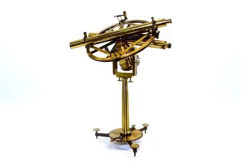
The Origins of Geodetic Heritage in the Netherlands and the former Dutch East Indies has a long history. With the growth of population in towns and cities and infrastructure, the need for reliable maps and records of property arose. Sea voyages also increased the demand for nautical maps. For the topographical and hydrographic services, both in the Netherlands and in the East Indies, surveyors and seamen were trained to map large areas. Measuring instruments and associated tripods, straightedge beacons and tools needed for this purpose have bequeathed extensive geodetic heritage over a period of four centuries. The lecture will focus on the instruments, measuring methods, results, people and institutions, which were needed for surveying on land and at sea. The results, shown on maps and in atlases, are impressive. Objects, still visible in the landscape today, also receive attention. The origins and preservation of geodetic heritage will be illustrated on the basis of a number of instruments and their applications. Institutions and museums involved will also receive attention. Also, the relationship with developments in geodesy in the field of climate and energy transition will be discussed.
For a comprehensive description and background information on the subject, a book was recently published by the speaker with hundreds of images of maps and measuring instruments used. The 200-page book, sewn-in with hard cover, will be available from the speaker during the break or immediately after the lecture.
Information about the speaker
Dr Huib Ekkelenkamp studied electrical engineering and telecommunications at Delft University of Technology, where he obtained his PhD in 2019 on "Indonesia on the map, the role of the Dutch presence in Indonesia, in the development of geodesy in the Netherlands". While employed by PTT, later KPN, he worked in the field of telecom network planning, including many years in Indonesia and in Central and Eastern Europe. As a result, he came into contact with land and sea maps and immersed himself in their origins and the geodetic measuring instruments and methods applied.
Based on his interest in new technical developments and the history of technology, particularly telecommunications, geodesy and cartography, he holds board positions at the Royal Institute of Engineers (KIVI) and at the De Hollandsche Cirkel Foundation for the Preservation of Geodetic Heritage.
Upcoming activities at Science Centre Delft:
- Saturday 22 November 2025 at 11:00 am lecture by Ir. R.J. de Heer: "Nine Centuries of Hydraulic Engineering as an Export Product".
- Saturday 20 December 2025 at 11:00 a.m. lecture by Ir. G.J. Luijendijk: "The Gliding Bridge across the World".
